Highlights
Significant achievements involving major logistical resources and Antarctic field work included:
Theme 1 ‑ Cryosphere-Ocean
Interaction: In
a pioneering voyage in early 2015, partly funded by the ARC SRI (with additional
support from AAD and ACE CRC), the Aurora
Australis became the first ship ever to reach the 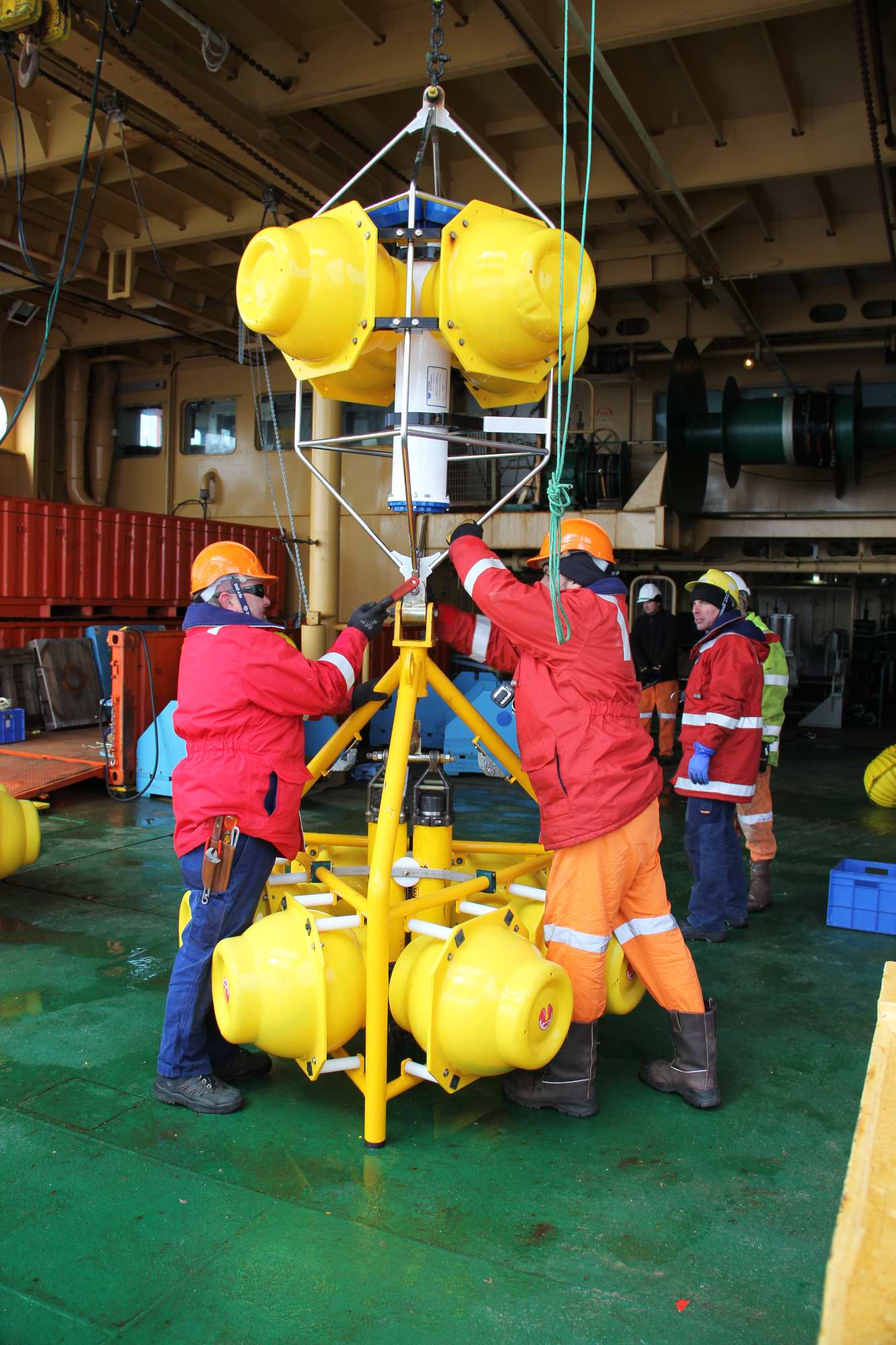 edge of East Antarctica's
fastest thinning glacier – the Totten Glacier. At 120 km long and more than 30
km wide the Totten Glacier is one of the world's largest and least understood glacial
systems. It drains 538,000 square kilometres of East Antarctica, an area more
than twice the size of the state of Victoria. Seventy billion tonnes of ice flow out of it
every year, enough to fill Sydney Harbour every two and a half days.
edge of East Antarctica's
fastest thinning glacier – the Totten Glacier. At 120 km long and more than 30
km wide the Totten Glacier is one of the world's largest and least understood glacial
systems. It drains 538,000 square kilometres of East Antarctica, an area more
than twice the size of the state of Victoria. Seventy billion tonnes of ice flow out of it
every year, enough to fill Sydney Harbour every two and a half days.
With a fortuitous break in the sea ice and skilled manoeuvring of the ship, Antarctic Gateway Partnership scientists were able to take the first direct measurements of the ocean alongside the front of the Totten Glacier. The expedition provided conclusive evidence that warm ocean water reaches the sub-ice shelf cavity, melting the ice shelf from below. Melting of the ice shelf is, in turn, linked to loss of mass from the grounded ice sheet and therefore sea level rise. This research demonstrates that the East Antarctic Ice Sheet is more vulnerable to ocean heat transport and likely to make a larger contribution to sea level rise than previously thought.
Photo credit: Steve Rintoul
Theme 2 ‑ Open Water and Under Ice
Food Webs: Around
one third of 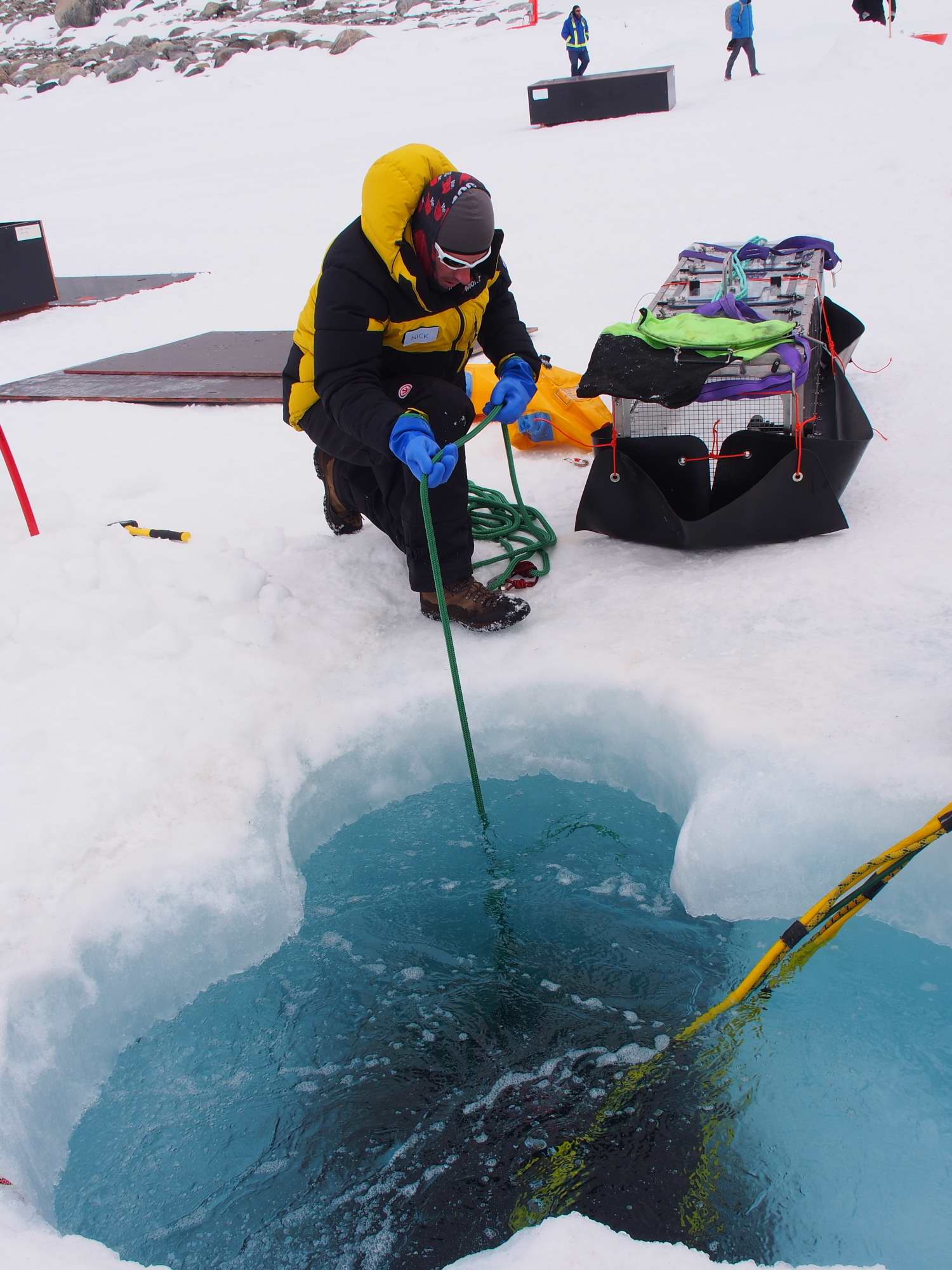 emitted anthropogenic carbon dioxide is absorbed by the ocean,
reducing ocean pH. This is termed ocean acidification or OA and will have
significant impacts on biological processes and serious implications for the
resilience of marine ecosystems. Free Ocean Carbon Enrichment (FOCE)
technology, developed by the Monterey Bay Aquarium Research Institute (MBARI)
for temperate waters,
was adapted and used to determine, for the first time, the vulnerability of
polar ecosystems to OA.The
Antarctic (antFOCE) project, led by the AAD, completed its first field season
in March 2015 at Casey Station, with a successful eight week acidification experiment
in the specially constructed benthic chambers. During 2015, the samples were
processed at the AAD and sent to various collaborators and laboratories around
the world for analysis.
emitted anthropogenic carbon dioxide is absorbed by the ocean,
reducing ocean pH. This is termed ocean acidification or OA and will have
significant impacts on biological processes and serious implications for the
resilience of marine ecosystems. Free Ocean Carbon Enrichment (FOCE)
technology, developed by the Monterey Bay Aquarium Research Institute (MBARI)
for temperate waters,
was adapted and used to determine, for the first time, the vulnerability of
polar ecosystems to OA.The
Antarctic (antFOCE) project, led by the AAD, completed its first field season
in March 2015 at Casey Station, with a successful eight week acidification experiment
in the specially constructed benthic chambers. During 2015, the samples were
processed at the AAD and sent to various collaborators and laboratories around
the world for analysis.
Photo credit: Glenn Johnstone
Theme 3 ‑ Solid Earth-Cryosphere
Interaction: All
three projects under this Theme benefitted from field work planned and
commenced in 2015 in East Antarctica and the Antarctic Peninsula involving
researchers from the US, UK and Australia. The projects were designed to
improve our understanding of present-day ice sheet contributions to sea level.
An initial database of crustal heat production has been created for Antarctica,
with a focus on East Antarctica. These efforts have focused on the collation of
already published estimates and the 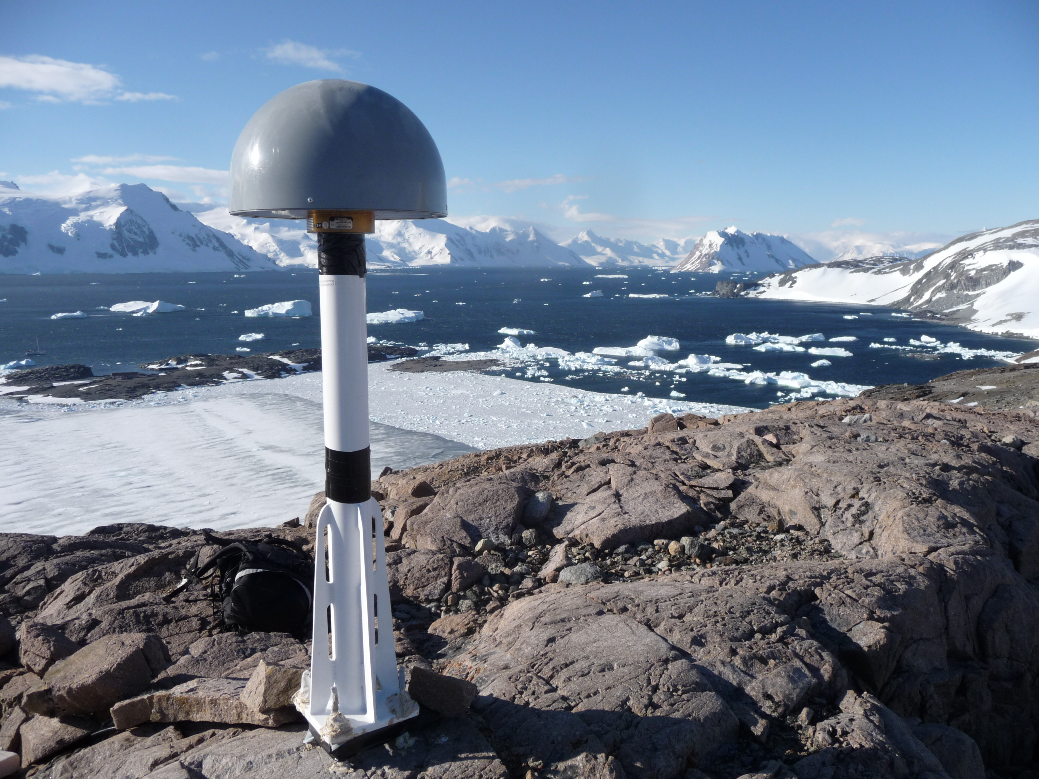 more sizeable task of analyzing existing
geological samples. The field work also included the collection of new geological
samples in East Antarctica from which crustal heat production values will be
obtained. New geological samples were obtained that, after analysis, will
provide dates associated with the retreat of the ice sheet between Australia's
Davis and Casey stations, a previously almost unsampled region spanning
>1,000 km. These new data will be used in future ice sheet modelling work to
produce robust estimates of past ice sheet extent and retreat. Samples were
collected near to Casey and Davis Stations as well as four remote rock outcrops
that will provide much needed field-based constraints. Photo credit: Matt Burke
more sizeable task of analyzing existing
geological samples. The field work also included the collection of new geological
samples in East Antarctica from which crustal heat production values will be
obtained. New geological samples were obtained that, after analysis, will
provide dates associated with the retreat of the ice sheet between Australia's
Davis and Casey stations, a previously almost unsampled region spanning
>1,000 km. These new data will be used in future ice sheet modelling work to
produce robust estimates of past ice sheet extent and retreat. Samples were
collected near to Casey and Davis Stations as well as four remote rock outcrops
that will provide much needed field-based constraints. Photo credit: Matt Burke
Theme 4 ‑ Marine Technology and Polar
Environments: Acquisition
of an innovative polar Autonomous Underwater Vehicle (AUV) is being co-funded
by the ARC Antarctic Gateway Partnership and UTAS - through 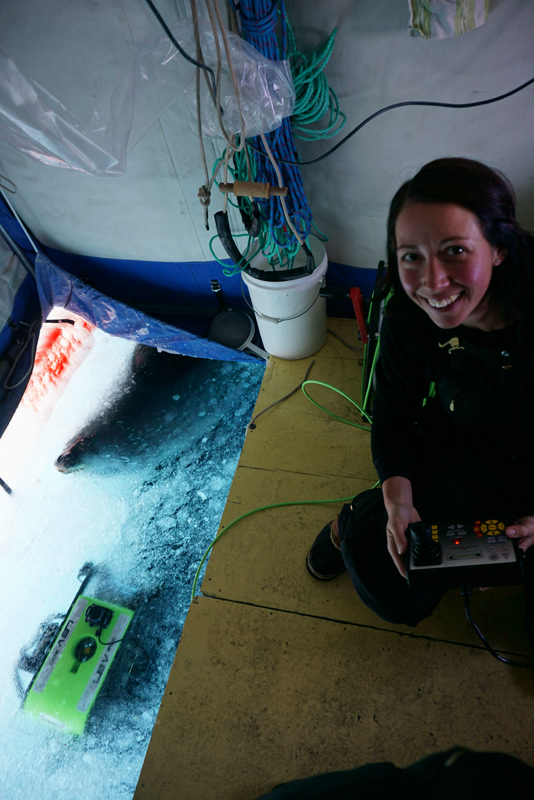 the Australian
Maritime College. Following consultation with potential science users, and
after a world-wide review of available AUVs and manufacturers, a detailed
specification was developed for the vehicle and its instrumentation. Tenders
were then called for Stage 1 - the vehicle acquisition with a base
instrumentation payload. Following the tender process, negotiations were
conducted with International Submarine Engineering (ISE), Canada and a contract
for purchase was finalized. Delivery is expected in the latter part of 2016 or
early 2017. Stage 2 - the acquisition, development and field trials of further
science tools has been initiated.
the Australian
Maritime College. Following consultation with potential science users, and
after a world-wide review of available AUVs and manufacturers, a detailed
specification was developed for the vehicle and its instrumentation. Tenders
were then called for Stage 1 - the vehicle acquisition with a base
instrumentation payload. Following the tender process, negotiations were
conducted with International Submarine Engineering (ISE), Canada and a contract
for purchase was finalized. Delivery is expected in the latter part of 2016 or
early 2017. Stage 2 - the acquisition, development and field trials of further
science tools has been initiated.
Photo credit: Alexander Forrest
Concurrently, to progress the development and testing of an instrument payload suitable for polar conditions, the AUV team collaborated with the Korean Polar Research Institute (KOPRI) to perform testing of a suite of instruments, including Inertial Navigation System (INS), sub-bottom profiler and multibeam sonar, in the Antarctic at the Drygalski Ice Tongue from the Korean research vessel RV Araon.
Research Activities
THEME 1 - Cryosphere - Ocean Interaction
Theme Leader: Dr Ben Galton-Fenzi (AAD)
1.1 - Physical oceanography: ocean-ice shelf interaction
Project
Leader: Dr Steve Rintoul (CSIRO)
PhD
Students: Wilma Huneke, Ole Richter
By soaking up heat and carbon dioxide from the atmosphere, the ocean slows the rate of climate change. In fact, global warming is really ocean warming: about 93% of the extra heat stored by the Earth over the past fifty years is found in the ocean. Of particular importance is the Southern Ocean, where ocean currents efficiently transfer water, heat and carbon between the sea surface and the deep sea. Given the strong influence of the region on climate, changes in the Southern Ocean would have widespread consequences. Measurements from ships and robotic floats show that significant changes are in fact already underway: the Southern Ocean is warming, freshening and becoming more acidic. In addition, evidence is growing that the Antarctic Ice Sheet is vulnerable to change in the surrounding oceans. In a pioneering voyage in early 2015, partly funded by the ARC SRI, the Aurora Australis became the first ship ever to reach the edge of East Antarctica's fastest thinning glacier – the Totten Glacier. With a fortuitous break in the sea ice and skillful maneuvering of the ship, scientists were able to take the first direct measurements of the ocean alongside the front of the Totten Glacier. The expedition provided conclusive evidence that warm ocean water reaches the sub-ice shelf cavity, melting the ice shelf from below. Melting of the ice shelf is, in turn, linked to loss of mass from the grounded ice sheet and therefore sea level rise. This research demonstrates that the East Antarctic Ice Sheet is more vulnerable to ocean heat transport and likely to make a larger contribution to sea level rise than previously thought.
1.2 - Glaciology and geophysics
Project Leader: Dr Chris Watson (UTAS)
Postdoctoral
Researcher: Dr Leo Peters
PhD Student: Eleri Evans
The Antarctic Geophysicist postdoctoral researcher associated with this sub-theme commenced in August 2015. The first field season of ground-based work was undertaken on the Sørsdal Glacier in East Antarctica during summer 2015-16 – this work involved collaboration with Dr Christian Schoof (University of British Columbia, Canada) and Dr Keith Nicholls et al (British Antarctic Survey, United Kingdom). An Automatic Phase Sensitive Radar (ApRES) unit and a Global Positioning System (GPS) receiver were deployed on the glacier, both of which are programmed to run continuously until next season (2016-17) to capture temporal details on ice flow, ice mass changes (thinning/stretching or thickening of the glacier) and basal melt; one seismic sounding was also made — this initial scoping season sets the stage for a more comprehensive ground-based campaign in 2016-17.
A successful proposal was led to acquire satellite imagery (72 high resolution Synthetic Aperture Radar [SAR] images) across the Sørsdal and East Ranvik Glaciers, East Antarctica over the next 3 years to capture spatial and temporal constraints on mass flux for these two outlet glaciers. A new collaboration was also generated via participation in a successful proposal to the New Zealand Antarctic Research Institute (NZARI), in collaboration with researchers from University of Otago, Victoria University of Wellington and University of Auckland, to explore deformation on the Ross Ice Shelf using seismic methods.
1.3 - Synthesis and modelling
Project Leader: Dr Ben Galton-Fenzi (AAD)
Postdoctoral
Researchers: Dr Felicity Graham, Dr David Gwyther
PhD Student: Madi Rosevear
Work in 2015 focussed on testing and developing ice sheet and ocean models for numerical simulations in key outlet glaciers of East Antarctica, namely the Totten Glacier and Amery Ice Shelf. The ice sheet and ocean models are currently being run to investigate the sensitivity of processes driving melting, both beneath ice shelves and ice sheets. A new high resolution (100 m spatial grid) bedrock topography terrain for the whole Antarctic continent was generated using data collected as part of the International Climate and Environmental Change Assessment Project (ICECAP) ‑ a collaboration between researchers primarily from the University of Texas at Austin's Jackson School of Geosciences, the University of Edinburgh, the University of Tasmania, and the Australian Antarctic Division. The high resolution terrain forms the basis for numerical model sensitivity studies assessing the impact of basal conditions on ice flow, initially focussing on the Totten catchment, then more broadly in East Antarctica. Several models have been run to investigate the different modes of variability affecting melting beneath the Totten Glacier from ocean processes. Investigating the important modes of oceanic variability - and hence the necessary observation length - before assimilating observations into models, will allow a better understanding of results in the context of climate variations.
THEME 2 - Open Water and Under Ice Food Webs
Theme Leader: Prof Philip Boyd (UTAS)
2.1 - Remote-sensing of water column and sea ice environmental change
Project
Leader: Assoc Prof Pete Strutton (UTAS)
Postdoctoral
Researcher: Dr Sebastien Moreau
Biogeochemical
Sensor Developer: Dr Christine McGraw
There were three main foci of Theme 2.1 in 2015. First, connections have been established with the US Princeton University-based Southern Ocean Carbon and Climate Observations and Modeling project (SOCCOM), and their Southern Ocean biological floats program, to provide a link to the ARC SRI Gateway Partnership float specifications, sensor package configuration, and area of deployment and enhance the existing US and international network of float deployments. Arrangements were made to purchase two Biofloats from Teledyne Webb Research in the US. Second, a postdoctoral researcher was hired with the desired skill set for Theme 2.1, and several IMAS graduate students have begun work on a range of projects that will add value to the core biological floats component of Theme 2.1. Third, a biological float deployment and monitoring project has been added to the RV Investigator voyage (during March-April 2016) and the biological floats project is linking with others on satellite remote sensing and detailed shipboard and underwater measurements. The latter includes the vertically-profiling Marine National Facility-purchased multi-sensor package (TRIAXUS), which makes high resolution maps of the upper 200 metres of the ocean for physical, chemical, biological and bio-optical properties.
2.2 - Remote-sensing of microbial responses to environmental change
Project
Leader: Prof Andrew McMinn (UTAS)
Postdoctoral
Researcher: Dr Andrew Martin
PhD Student:
Fraser Kennedy
Work in 2015 focused on acquiring key equipment, namely a custom-designed sea ice tank, and engaging staff, a postdoctoral researcher and PhD students. Construction of the ice tank has been completed and it is undergoing comprehensive testing in the IMAS Waterfront Building. It is anticipated that testing with microbial communities and micro sensors will continue until June 2016.
Research has commenced on the response of sea ice microalgae (cultures of Fragilariopsis cylindrus) to extended periods of both high irradiance and complete darkness. Both of these phenomena are natural seasonal features of life in polar oceans. The aim is to determine what proteins and which metabolic pathways are regulated and to link them with biochemical pathways and cellular physiology.
Pairing proteomics with more traditional algal physiological measurements are likely to provide new insights into novel proteins and pathways that may be important in polar biogeochemical cycling and microbial loop dynamics.
2.3 - Ecological effects of ocean acidification
Project Leader: Dr Jonny Stark (AAD)
PhD Student:
Alyce Hancock, Helene Aflenzer
Around one third of anthropogenic carbon dioxide (CO2) emitted is absorbed by the ocean, reducing ocean pH (termed ocean acidification or OA), which will have significant impacts on biological processes and serious implications for the resilience of marine ecosystems. Free Ocean Carbon Enrichment (FOCE) technology, developed by the Monterey Bay Aquarium Research Institute (MBARI) for temperate waters, was adapted and used to determine, for the first time, the vulnerability of polar ecosystems to OA.
The Antarctic Free Ocean Carbon Enrichment (antFOCE) project completed its first field season in March 2015 at Casey Station, with a successful eight week acidification experiment in the benthic chambers. At the end of the experiment all equipment was retrieved from the seabed and returned to Australia. A large number of samples were collected at the end of the experiment and returned to Australia for analysis. During 2015, the samples were processed at the AAD and sent to various collaborators and laboratories around the world for analysis.
The experiment has a multidisciplinary holistic approach, examining a wide range of benthic communities from microbes to macrofauna. Collaborators at Plymouth Marine Laboratory, UK are examining effects on bioturbation rates, meiofaunal communities and sediment nitrification processes. Collaborators at CSIRO are examining carbonate chemistry and microbial communities (in sediments) using genomic techniques. Collaborators at UTAS are examining microbial communities (in biofilms) using genomic techniques. Collaborators at AAD are examining macrofaunal communities, eukaryotic communities (using genomic techniques), sediment chemistry and microphytobenthos. US collaborators at Monterey Bay Aquarium Research Institute (MBARI) are examining carbonate chemistry and the modifications made to the antFOCE system from the MBARI xFOCE designs. Collaborators at the University of NSW are examining encrusting communities on hard substrates, particularly calcium carbonate shell builders. Collaborators at the Natural History Museum of Denmark/Copenhagen University are examining links between sediment eukaryotic communities and environmental DNA.
In late 2015 as part of the antFOCE project, a seapHox (pH and dissolved oxygen sensor) unit - was deployed on the seabed at Casey, at the antFOCE experiment site. This will record a high resolution measurement of pH of coastal seawater over a 12 month period. Such data sets are lacking in the Southern Ocean and will provide valuable baseline information on pH variation in coastal waters and provide an important context for the antFOCE project.
2.4 - Food web dynamics of mesopelagic organisms
Project Leader: Prof Mark Hindell (UTAS)
Postdoctoral
Researcher: Dr Andrea Walters
The Mesopelagic
Ecologist postdoctoral researcher for Project 2.4 commenced in June 2015. She
developed an overall 3-year research plan aimed at building our understanding of environmental controls on fish
and other marine taxa such as cephalopods that specifically live at depths
between about 200 and 1,000 metres, commonly referred to as the mesopelagic
zone. The distribution of mesopelagic fish and their main predators – marine
mammals including seals, penguins and toothed whales and flying birds – may
indicate the structure of lower 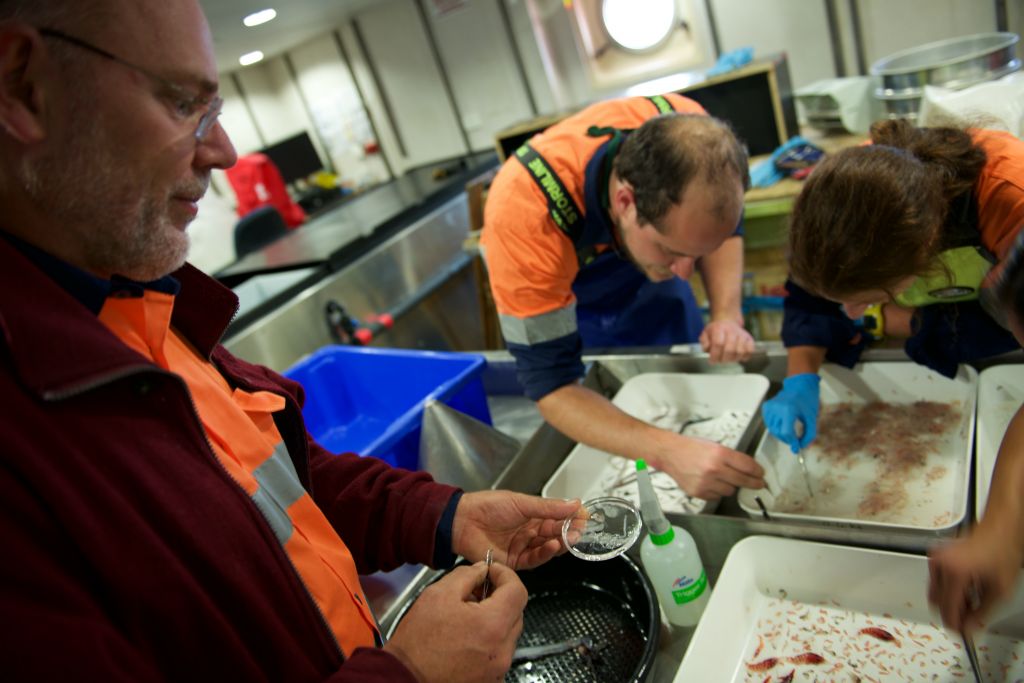 feeding levels within ecosystems. Developing
better quantification of the energy pathways mediated by mesopelagics is
therefore an important step in understanding the wider ramifications of shifts
in the flows of energy between feeding levels within ecosystems.
feeding levels within ecosystems. Developing
better quantification of the energy pathways mediated by mesopelagics is
therefore an important step in understanding the wider ramifications of shifts
in the flows of energy between feeding levels within ecosystems.
Photo Credit: Nick Roden
In 2015, Dr Walters worked with Prof Philippe Koubbi (Université Pierre et Marie Curie, France) and Dr Rowan Trebilco (ACE CRC) to develop a detailed work plan for the research to be conducted on the Kerguelen Axis (K-Axis) two month marine science cruise of Aurora Australis which departed from Hobart in January 2016. The Voyage Chief Scientist was Dr Andrew Constable (AAD) from Theme 2. The overall aim of the voyage was to investigate the potential tipping points for ecosystems in the Southern Ocean. A key objective of the voyage was to elucidate the environmental and biogeochemical drivers responsible for the transition between the northern copepod-fish dominated food web in the Southern Ocean to the krill-based food web closer to Antarctica. Dr Walters led a team of scientists, including Dr Rowan Trebilco (ACE CRC), Dr Sophie Bestley (AAD), Assoc Prof Zhu Guoping (University of Shanghai for Science and Technology, China) and Dale Maschette (AAD) to investigate the distribution and abundance of mesopelagic fish. Fish assemblages were measured using deployments of a depth-stratified mid-water trawl net and active acoustics (led by Dr Martin Cox, AAD). The results of this study will form a key component of Dr Walters's work within Theme 2 to increase our understanding of the structure and function of mesopelagic components of Southern Ocean food webs, and the likely response of mesopelagic species to environmental change.
Dr Walters also began a stable isotope database in collaboration with the Scientific Committee on Antarctic Research's (SCAR) Expert Group on Birds and Marine Mammals (EG-BAMM) and the French Centre National de la Recherche Scientifique (CNRS).
THEME 3 - Solid Earth-Cryosphere Interaction
Theme Leader: Prof Matt King (UTAS)
3.1 - Solid Earth deformation
Project Leader: Prof Matt King (UTAS)
Postdoctoral
Researcher: Dr Lenneke Jong
PhD Student:
Doreen Warjri
Fieldwork-based
projects were planned and commenced in 2015 in East Antarctica and the
Antarctic Peninsula involving researchers from the US (Prof Eugene Domack,
University of South Florida; Dr Erin Pettit, University of Alaska, Fairbanks),
UK (Dr Pippa Whitehouse; Prof Michael Bentley) and Australia (Dr Duanne White,
University of Canberra; Dr Paul Tregoning, Dr Simon McClusky, Australian National
University). The projects are both designed to improve our understanding of
present-day ice sheet contributions to sea level using the Gravity and Recovery
Climate Experiment (GRACE) satellite mission. They specifically address the
characteristics and origins of present-day mass change within Earth's mantle,
and provide new information on the evolution of the ice sheet in these regions
in the past that drive these changes. The East Antarctic fieldwork is supported
through Australian Antarctic Science project AAS 4318 (CI Prof Matt King, UTAS).
Antarctic Peninsula equipment is part-funded through ARC LIEF LE150100108 (CI
Prof Matt King, UTAS).
of present-day mass change within Earth's mantle,
and provide new information on the evolution of the ice sheet in these regions
in the past that drive these changes. The East Antarctic fieldwork is supported
through Australian Antarctic Science project AAS 4318 (CI Prof Matt King, UTAS).
Antarctic Peninsula equipment is part-funded through ARC LIEF LE150100108 (CI
Prof Matt King, UTAS).
Photo credit: Russ Hepburn
Analysis of existing datasets focused on the response of the solid earth to the sustained thinning of glaciers in the Southern Antarctic Peninsula, showing a relatively low viscosity mantle in this region, although an order of magnitude higher than that in the Northern Antarctic Peninsula. While previous work has examined the vertical deformation pattern observed using Global Positioning System techniques, extension was made to include horizontal velocities revealing that the two components are complementary in constraining ice sheet models and suggesting the spatially complex earth structure in this region needs to be considered to fully understand the rheology of the asthenosphere and mantle.
3.2 - Geothermal heat flux
Project
Leader: Assoc Prof Anya Reading (UTAS)
Postdoctoral
Researcher: Dr Jacqui Halpin
PhD
Students: Isabel Sauermilch, Tobias Stahl
With the appointment of an experienced postdoctoral researcher an initial database of crustal heat production has been created for Antarctica, with a focus on East Antarctica. These efforts have focused on the collation of already published estimates and the more sizeable task of analyzing already collected geological samples. Collaborations are being established with researchers at University of Adelaide to allow more efficient sampling of geological samples for radiogenic elements that produce crustal heat. The assessment of heat production from within the mantle, as well as an understanding of crustal heat production within the vast areas of Antarctica covered by ice, requires assimilation of various datasets and models. Significant effort has focused on understanding the uncertain and disputed geological makeup of East Antarctica through a combination of geological sample analysis in the ice free zones combined with numerical modelling of plate tectonics over deep time.
The fieldwork described under Theme 3.1 also included the collection of new geological samples in East Antarctica from which crustal heat production values will be obtained.
3.3 - Paleo ice sheet modeling
Project
Leader: Dr Jason Roberts (AAD)
Postdoctoral
Researcher: Dr Steven Phipps
John Stocker
Fellow: Dr Taryn Noble
A postdoctoral appointment was made in the fields of ice sheet modelling and marine constraints on past ocean conditions. The fieldwork described under Theme 3.1 also obtained new geological samples that, after analysis, will provide dates associated with the retreat of the ice sheet between Australia's Davis and Casey stations, a previously almost unsampled region spanning >1,000 km. These new data will be used in future ice sheet modelling work to produce robust estimates of past ice sheet extent and retreat. Samples were collected near to Casey and Davis Stations as well as four remote rock outcrops that will provide constraints. Preliminary field evidence suggests that the ice sheet in this region was not substantially larger than present-day at the Last Glacial Maximum. Preparatory efforts were made for the airborne mapping of offshore bathymetry using airborne gravimetry within the International Climate and Environmental Change Assessment Project (ICECAP) with researchers from the US (Don Blankenship) and UK (Martin Siegert).
Ice sheet modelling work has focused on initial model setup and the consideration of the interactions within the coupled ice sheet/ocean/solid system. Two distinct model frameworks are being constructed: the first focused on single glacier systems with full Stokes model formulation and is closely aligned to Theme 1; the second is focused on all-of-ice-sheet system with simplified physics that are appropriate to long time period (~20,000 years) model runs. Both model setups are exploring appropriate parameterisations of presently unmodelled, or poorly modelled, solid earth response to ice loading changes, which may stabilise or slow ice sheet retreat; in particular the importance of low viscosity mantle, and hence rapid solid earth response is being explored for the first time. The implementation of alternative ice flow and sliding relations have also begun, allowing testing of past theoretical developments from the Hobart group in numerical simulations for the first time. Model solutions were obtained that demonstrated the response of the Southern Ocean to freshwater input from melting ice, namely increased stratification of surface waters and changes in production of Antarctic Bottom Water.
THEME 4 - Marine Technology and Polar Environments
Theme Leader: Prof Neil Bose (AMC)
4.1 - Development and acquisition of a polar-capable Autonomous Underwater Vehicle (AUV)
Project
Leader: Prof Neil Bose (UTAS)
AUV Research
Leader: Dr Vanessa Lucieer
AUV Postdoctoral
Researcher: Dr Damien Guihen (from 2016)
AUV Facility
Coordinator: Peter King
AUV
Engineer: Dr Konrad Zurcher
AUV Junior
Engineer: Isak-Bowden-Floyd
Acquisition of an innovative polar Autonomous Underwater Vehicle (AUV) is being co-funded by the ARC Antarctic Gateway Partnership and UTAS - through the Australian Maritime College. Following consultation with potential science users, and after a world-wide review of available AUVs and manufacturers, a detailed specification was developed for the vehicle and its instrumentation. Tenders were then called for Stage 1 - the vehicle acquisition with base instrumentation payload. Following the tender process, negotiations were conducted with International Submarine Engineering (ISE), Canada and a contract for purchase was finalized. Delivery is expected in the latter part of 2016. Stage 2 - operational trials and the acquisition and development of further science tools – has been initiated and the trials will commence in early 2017.
A tender was awarded by UTAS for a new AUV Facility building refurbishment at the AMC in Launceston. The building and laboratory, funded by UTAS at a cost of $750,000, will be capable of housing a wide range of equipment including the new polar AUV. Building works are expected to be completed in late 2016.
The AUV team collaborated with the Korean Polar Research Institute (KOPRI) to perform testing of Inertial Navigation Systems (INS) at high latitudes, testing of a sub-bottom profiler in ice, and multibeam sonar collection in the Antarctic at the Drygalski Ice Tongue from the Korean research vessel RV Araon. Instrument makers, including iXBlue, iXSurvey, and Edgetech, contributed equipment and collaborated in the trials.
The AUV team was successful in applying for berths and project support on two upcoming RV Investigator cruises (V03 – April 2016 and V05 – October 2016). The first of these is for a student to participate in inertial navigation system (INS) trials across 65 degrees of latitude (the equator to the marginal ice zone). The second of these will be investigating the challenges associated with mapping drifting and rotating frames of reference.
4.2 - Sea ice charting and forecasting
Project
Leaders: Dr Philip Reid (BOM), Prof Tony Worby (ACE CRC)
Researchers:
Dr Jan Lieser (Sea ice charting), Dr Laura Davies (Sea ice forecasting)
Sea ice
charting: During the 2014-15 Antarctic season, sea-ice analysis and charting
was provided to national and international Antarctic operations. In addition to
regular written Sea Ice Reports, near-real time imagery was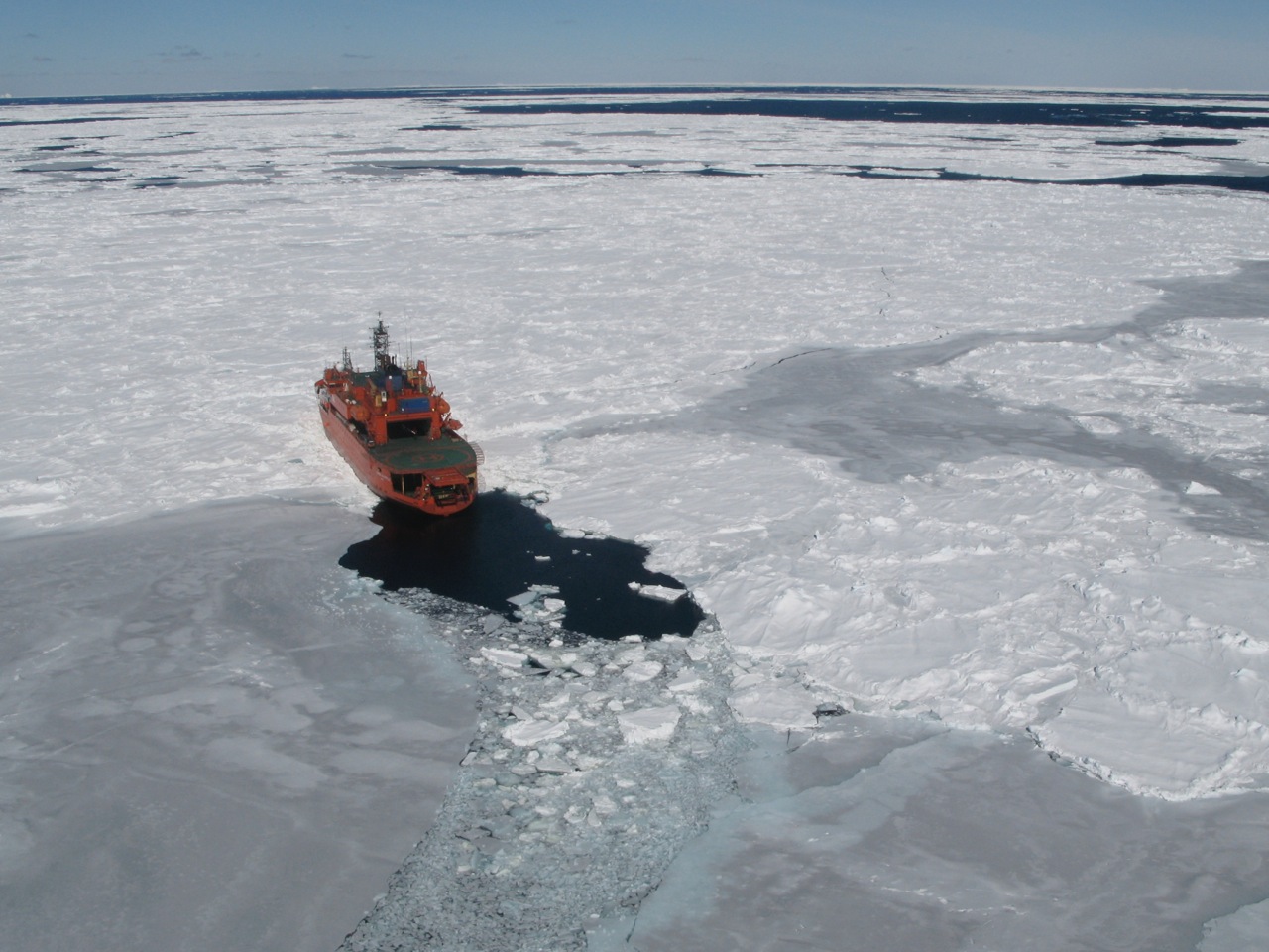 delivered to the
operators. Seven institutions from five nations on sixteen voyages were
supported. Following the Antarctic shipping season, a review and summary report
was published as an ACE CRC Technical Report. From late September, sea-ice
reporting commenced again for the 2015-16 season.
delivered to the
operators. Seven institutions from five nations on sixteen voyages were
supported. Following the Antarctic shipping season, a review and summary report
was published as an ACE CRC Technical Report. From late September, sea-ice
reporting commenced again for the 2015-16 season.
Sea ice forecasting: A postdoctoral Sea Ice Forecasting Researcher was appointed in July 2015 to work on the performance of sea ice within ACCESS-S (seasonal version of the Australian Community Climate and Earth-System Simulator) model that will be running within the Bureau of Meteorology.
Photo credit: Jan Lieser
A PhD candidate was recruited to commence in early 2016 to work on an improved version of ACCESS-G (global numerical weather prediction model) that will better simulate high-latitude conditions through the inclusion of polar specific physics.